Expédition de Chine en 1860 : atlas dressé d'après les documents officiels sous la direction du lieutenant de vaisseau Pallu, 1863
Expédition de Chine en 1860 : atlas dressé d'après les documents officiels sous la direction du lieutenant de vaisseau Pallu, 1863
1860年第二次鴉片戰爭地圖集
作者(Author):Pallu (Lieutenant de Vaisseau) ed.
出版社(Publisher): Dépôt de la marine, Paris
出版時間(Publishing Date):1863
頁數(Pages):8 maps
裝幀(Binding):Hardcover
品相(Condition):Fair
尺寸(Size):50x37.5cm
Published in 1863 by the French Dépôt de la marine to accompany the Relation de l’expédition de Chine en 1860, documenting the Franco-British expedition to China during the Second Opium War. It was compiled under the direction of Lieutenant de vaisseau Léopold Augustin Charles Pallu de la Barrière, who participated in the campaign and later became a rear admiral.
The atlas contains eight finely engraved maps and plans, five of which are double-page, providing detailed geographical and military documentation of the expedition:
-
Carte pour servir à l’intelligence des Opérations sur les Côtes de Chine – General map of operations along the Chinese coast.
-
Plan de la Ville de Shan-ghai – Plan of the city of Shanghai.
-
Plan de la Rade de Tché-Fou – Plan of the roadstead of Chefoo (Yantai).
-
Plan de Peh-Tang-Ho et de Pei-Ho – Plan of the Pehtang and Peiho Rivers.
-
Plan de l’Occupation de Tien-Tsin – Map showing the occupation of Tianjin.
-
Carte de Pei-Ho – Detailed chart of the Peiho River.
-
Plan de l’embouchure du Pei-Ho et de l’Itinéraire suivi de Ta-Kou à Tché-Fou – Plan of the Peiho estuary and route from Dagu to Chefoo.
-
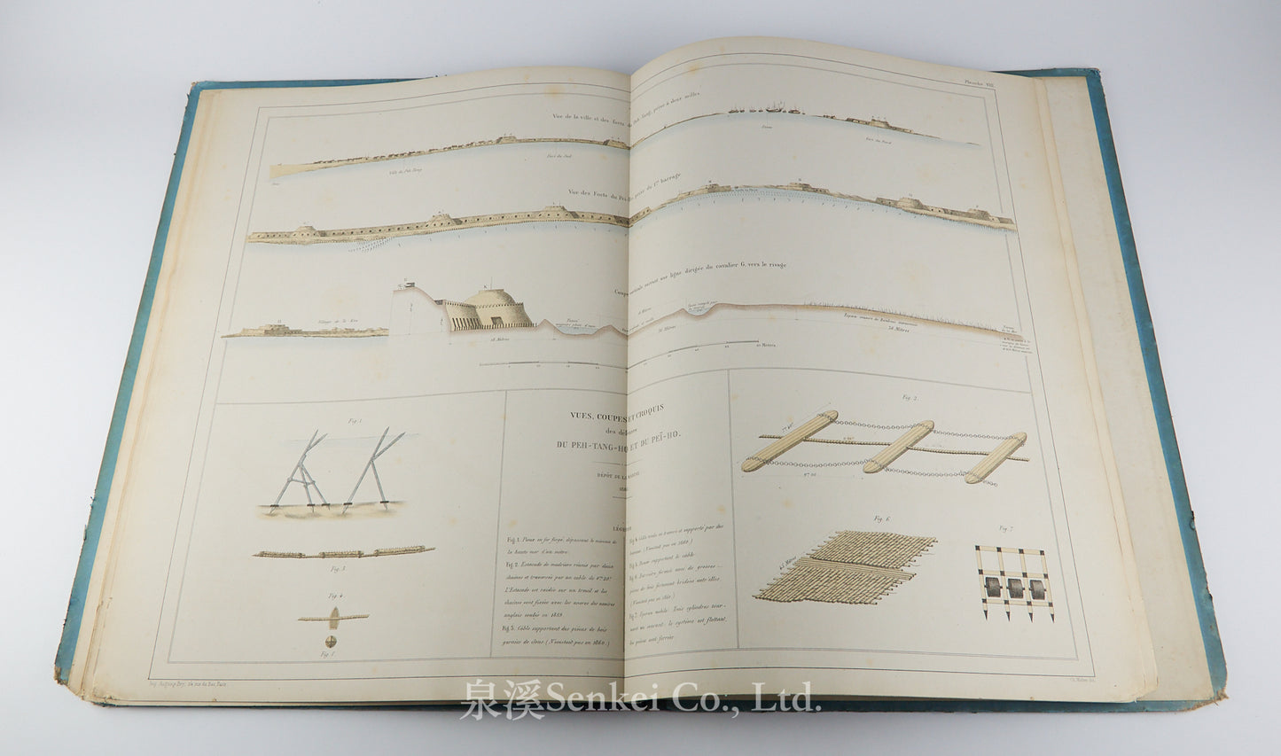
Vues, Coupes et Croquis des Défenses du Peh-Tang-Ho et de Pei-Ho – Views, cross-sections, and sketches of the defenses along the Pehtang and Peiho Rivers.
Richly detailed and precisely executed, the atlas offers one of the most important cartographic records of the 1860 campaign.
Covers slightly rubbed and soiled. The inner hinge shows some splitting with visible binding threads, and the binding is slightly loose.
地圖目錄
-
中國沿海作戰形勢圖
Carte pour servir à l’intelligence des Opérations sur les Côtes de Chine
(顯示法英聯軍於中國沿海之行動總圖) -
上海市街平面圖
Plan de la Ville de Shan-ghai
(上海市區及主要設施分佈圖) -
芝罘港灣圖
Plan de la Rade de Tché-Fou
(今山東煙臺港灣地圖) -
北塘河與北運河平面圖
Plan de Peh-Tang-Ho et de Pei-Ho
(描繪北塘河與北運河河道及防禦工事) -
天津佔領區圖
Plan de l’Occupation de Tien-Tsin
(顯示法英聯軍於天津之佔領與防線) -
北運河全圖
Carte de Pei-Ho
(北運河流域航線與周邊地勢詳圖) -
北運河入海口及自大沽至芝罘行軍路線圖
Plan de l’embouchure du Pei-Ho et de l’Itinéraire suivi de Ta-Kou à Tché-Fou
(自大沽口至芝罘之行軍及運輸航路圖) -
北塘河與北運河防禦工事之立面、剖面與略圖
Vues, Coupes et Croquis des Défenses du Peh-Tang-Ho et de Pei-Ho
(防禦工事、炮台及壕溝結構示意圖)
封面略有磨損和污漬,書籍內側有開裂。
Ask a Question